“75 men digging graves on the hillside, a depot platform piled high with pine boxes, a row of coffins in the main street stacked 3 high and nearly a block in length, a corps of undertakers as large as a regiment’s hospital corps, women whose eyes could weep no more, with orphaned children clinging to their skirts—these were some of the evidences that there would be no Christmas in Monongah for another year.” (Forbes)
~ Noon
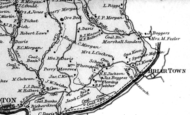
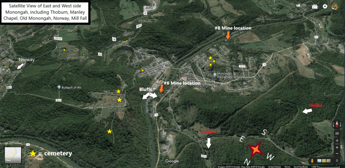
In Monongah:
“Many newspaper men, including photographers, from all over the country are at Monongah. All of the nearby cities have special reporters on the scene and there are newspaper men from Pittsburg, Wheeling, Cincinnati, Cleveland, Washington and other cities.” (CDT 12.8.07 pg. 1)
“Probably never before on any occasion have the interurban cars carried as many people as they have in the last few days since the mine disaster. All along the line hundreds of anxious people are found at every station eagerly trying to get on a car to go to the scene of the disaster. Many of them are foreigners who had relatives working in the two mines. Sunday the interurban station in this city was crowded all day and many people visited the scene of the disaster. The street cars were run double all day and every one was crowded to its utmost. Many people took advantage of it being Sunday, to go to Monongah.” (CDT 12.8.07 pg. 1)
Inside the mines:
“The farther into the mines the workers proceed the greater the destruction is found to be. Many side entries and rooms are completely blocked by falls of slate. One room where it was known two of the miners were working was entered but instead of finding the blackened bodies of the two miners tons and tons of slate were found burying them so that it will be several days before their bodies can be recovered. The same condition of affairs is reported at many other points in the mine.” (US Dept of Labor-mine disasters-Dispatch article)
Outside the mines:
“Finally, a horse came out of the hill and behind it a train of empty mine cars but the last car was loaded and covered with stained canvas and blankets. The coverings were thrown off and one by one the blackened and mutilated bodies of what had once been men were carried to the waiting wagons to be hauled over the bridge into the town and delivered to the undertakers.” (Forbes)
“They all looked as if they had been par-boiled, they were so red. Many of them were mutilated and in several cases the eyeballs had been split by the force of the explosion. The bodies were beginning to decompose.” (CET 12.10.07 pg. 6)
~2:00 pm
Col. J. H. McDermott arrives in Fairmont as representative of Gov. Dawson, who was unable to come to the scene of the Monongah disaster. Judge J.W. Mason and Clerk W.T. Black met him at the train station. (FWV 12.9.07 – pg. 1 – extra) (FWV 12.9.07 pg. 1)
“I am here to look over the situation,” said Col. McDermott, “and will advise Gov. Dawson from time to time what I learn. I am not here to interfere with any department of the mines, as each representative of every department will adhere strictly to his own work.” (WH 12.9.07 pg. 1)
“At the last meeting of the State legislature Col. McDermott, in his capacity as President of the Senate, appointed a committee to investigate the mines of West Virginia and the mine disasters. This committee had visited both the mines at which the explosion took place, about two months ago, and pronounced them as being as finely equipped and managed as any they had ever seen. It is quite probable that this same committee will arrive here shortly for another examination of the Monongah mines.” (WH 12.9.07 pg. 1)
At some point during the afternoon
In Fairmont:
“This town has some plucky girls, and it is a question as to whether their equal can be found. …Sunday there were 4 of them walked to Monongah, across the hill, taking all the near cuts and making the distance as short as possible. That’s game, that is.” (FWV 12.16.07 pg. )
“Headed by the churches, relief work was well started yesterday and a general appeal to the public is being made. Many West Virginia towns have already acted and others are ready to do so. The work will be thoroughly organized and systemized.” (ES 12.9.07 pg. 1-2)
“Relief corps were organized by the women of Fairmont today. Already hundreds of dollars are pouring in.” (WH 12.9.07 pg. 1)
In Morgantown:
Collections from all Morgantown churches are handed over to relief funds. (FWV 12.9.07 pg. ?)
At the morgue in Monongah:
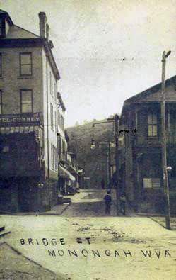
“R.L. Cunningham, of Fairmont, who is one of the undertakers who have charge of the band of fifteen caring for the bodies brought out of the mines, preparing them for burial and placing them in coffins, met with an accident that has laid him up. While hurrying from the morgue in the First National Bank building on Main street to one of the branch morgues, he slipped and fell, spraining a weak knee joint so badly that he cannot walk. He is confined to his room in the Curry hotel under care of a physician and his work has devolved upon another undertaker. Messrs. W.G. Osborn and Sleppy & Warne, of this city, are still with the undertakers assisting in the work of taking care of the dead.” (CDT 12.8.07 pg. 1)
At the cemeteries:
“About twenty victims were buried today in the three cemeteries near the town.” (AMJ 12.9.07 pg. 1)
“The bodies of fifteen Italians were buried in Holy Cross cemetery Sunday afternoon. The cemetery is located on the hill over the mines. The bodies of two Polanders were also buried the same afternoon in the Polish cemetery which is on the same hill adjoining Holy Cross cemetery. The bodies of two Polanders are lying in the Polish church where services will be held over them.” (CDT 12.9.07 xtra pg. 1) (CDT 12.9.07 xtra pg. 10)
In Monongah:
“Another woman, the mother of five little children, whose husband was killed in mine No. 8, became so distracted at her home that she began throwing household articles about the house and then to tear her clothing from her. She became so violent that friends had to tie her to a chair and stand watch over her until she became quieted.” (CDT 12.8.07 pg. 1)
“The body of Fred Rogers was taken to Fairchance Sunday afternoon and buried there.” (CDT 12.9.07 xtra pg. 1) (CDT 12.9.07 xtra pg. 10)
“…3 men who were thought to be victims but escaped are Ross Morka, Marie Bagenealla and Anebra Spaw. The 2 former went to Clarksburg to visit some friends early in the morning of the explosion but did not notify their boarding boss of their intentions. They were given a royal reception when they appeared today. Spaw, one of the men supposed to have been blown into the river at the entrance of No 6 was not at work that fateful morning. When he learned that his friends were mourning him as dead he lost no time in returning from a visit to Grafton.” (US Dept of Labor-mine disasters-Dispatch article)
At the mines:
“But 3 bodies have been removed from No 8 mine this afternoon, two being those of a motorman and a brakeman found near their car at the first left entry of the north heading near where the third body was found. All were badly burned about the face and hands but friends were able to recognize them at the morgue.” (US Dept of Labor-mine disasters-Dispatch article)
“A thrilling incident occurred on the bridge on which the mine cars were pulled from mine No. 8 in which an aged Polish woman nearly lost her life. Her only son, and the bread winner of the family, was killed in the awful explosion. She wandered out on the bridge and was climbing on some planks used as a temporary walk and was viewing the workers about the wreckage in front of the mine. Suddenly she staggered and fell. Several men ran to her side and caught her just as she was falling into the river. Friends carried her away in hysterics.” (CDT 12.8.07 pg. 1)
In McKeesport, PA:
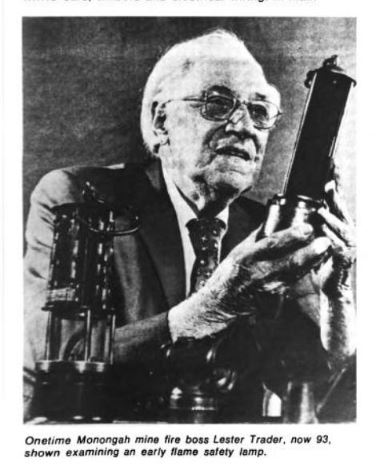
Lester E. Trader and his brother are at their father’s home in McKeesport when General Manager Frank Haas “… called up and said he wants us to get back here. Frank and I couldn’t leave the company that way. I went back and they gave me a job in the auditor’s office in Clairmont.” (McAteer)
Victor told Trader that in return for being given an office and a job in the accounting department, he would be quoted as official spokesperson for company. (McAteer)
In Fairmont:
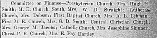
The Union Relief Association is organized at the Methodist Protestant Temple for the purpose of receiving and distributing aid of all kinds to the stricken families in and about Monongah and is rapidly shaping plans through the various committees, to do the necessary work in a thoroughly business-like way. (FWV 12.9.07 pg. ?)
Collections from the morning’s church services are turned over to Mrs. Thomas W. Fleming, “who will see that it does the most possible good to lessen burdens that the grief-stricken ones are bearing.” (FWV 12.9.07 – pg. 1 – extra)
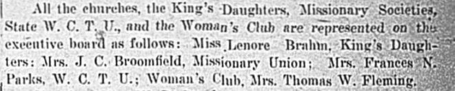
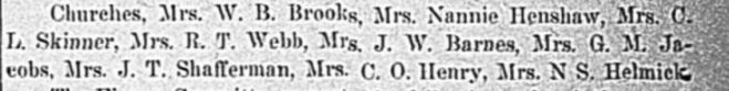
“Donations of money can be handed to any member of the following committee and receipt for the same will be sent to the donor by Mrs. Thomas W Fleming, chairman.”

~2:30 pm
Chief Mine Inspector J.W. Paul goes into #6 to inspect conditions. (McAteer)
“At both mines members of rescuing parties are being taken from the mines weakened and unconscious condition but after being out for a few hours they have fully recovered. None of the rescuers who have been overcome is now in serious condition.” (US Dept of Labor-mine disasters-Dispatch article)
At the morgue:
“One thing that is considered strange is that few things of value are being found among the effects of the dead. From information received from the company officials Coroner Amos was of opinion that large sums of money would be found in the clothes of the foreign miners and working upon this supposition a careful search was made of every garment removed from the body. It was known to be a custom of the foreigners to carry their money with them, but the most valuable article so far found was a silver watch in the pocket of Peter Alexander, who was removed to the morgue Sunday afternoon.” (CDT 12.9.07 pg. 1)
~3:00 pm
At #8:
“All Sunday until 3 o’clock in the afternoon, when the searching parties were ordered out so that the mine inspectors make a test and experiment with the new fan at No. 8, there were sixty men engaged in the work of recovering bodies and nearly a score were taken out during the day.” (CDT 12.9.07 xtra pg. 1) (CDT 12.9.07 xtra pg. 10)
*For the past 32 hours or so, all of the local mines owned by Fairmont Coal Company have been shut down and those miners have been reporting to Monongah for work. 2 small fans on loan from local smaller mines have been circulating air into #8. With rescue and recovery work now formally systemized under Inspector Paul and the other state inspectors and a plan to regularly change out volunteer crews, Fairmont Coal Company intends to restart regular work in their other local mines tomorrow.
*A replacement fan is currently is on its way from Pittsburg and scheduled to arrive on a special train around 4 pm. One of the fans is to be switched out and sent back to its original mine so that regular work may resume there tomorrow.
*Around 3 pm General Manager Frank Haas, who has been in charge of overseeing work at #8, begins to put their devised plan for switching out the fans into action. A majority but not all miners are ordered out of #8 just before one of the 2 fans is switched off. The outside crews are prepared to begin unmounting the fan from its temporary housing and get it across the trestle to the railroad line.
*Inside #8, small “hot spots” in explored and still unexplored areas of the mine (where coal is smoldering and radiating heat but there is not enough oxygen to ignite flame or smoke) become fully deprived of air. As the coal burns, it continues to release methane gases, but the air circulation is not powerful enough anymore to disperse or dilute these gases. Those who are permitted to remain in the mine during the fan switch are more than likely those who are working near or in the direct path of the 2nd fan which is not turned off.
*At #6, men are also ordered out at this time as the air current from #8 will likely push dangerous gases into the workings of #6.
“The work at No 6 progressed rapidly owing to the conditions of the powerful fan there, until the rescuers were ordered from the mine because of the temporary cessation at No 8.” (US Dept of Labor-mine disasters-Dispatch article)
“After the men were ordered to cease temporarily from the rescue work at No. 6 the opening was closed and late in the day the big new fan was set to work at No. 8. One reason for the ordering of the men out was the discovery of some gas at the connection of the two mines, and another was that it was the purpose to divert the air-course from No. 8 into No. 6, thus making it dangerous for men to work in No. 6. While this was going on a heavy guard was placed on the city side of the bridge running across the river to the tipple and no one was allowed to cross there, lest there might be a deadly current of air out of No. 6 at any moment.” (CDT 12.9.07 xtra pg. 1) (CDT 12.9.07 xtra pg. 10)
~4:00 pm
In Monongah:
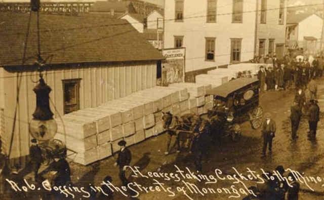
The Company hires 3 Fairmont undertakers to manage the bulk of transporting the dead: Musgrove & Sons, R.I. Cunningham, and Jones & Co.; these 3 hire on 20 more undertakers from Fairmont and surrounding towns. (McAteer)
Unfortunately, the undertaker transport drivers are not very familiar with area of Monongah. Much confusion occurs over the next days in the transport of bodies to the correct homes. Priests will end up helping with most. (McAteer)
“The rapidity with which the remains began to be recovered late this afternoon and evening necessitated the coal company pressing into service a number of transfer wagons. These were filled with straw and the gruesome work of carting the charred remains across the river through the dense crowd began. Scenes that were sublimely pathetic transpired. The weeping of the bereaved ones as they madly chased after the vehicles was heartrending. They overwhelmed the morgue in their clamors for a look at the dead and it was necessary to drive them back by force and draw ropes across the main street. Pickets were stationed and the crowd thus held in check. It would only separate when the carriages of death were forced through to take the bodies to the cemeteries.” (US Dept of Labor-mine disasters-Dispatch article)
At #8:
*The anticipated 4 o’clock B&O special train arrives carrying very important materials for the rescue efforts and, more than likely, Paul U. Kellogg and several others who will become key figures over the next few days
“The victims at Monongah were working with open lamps on their caps; it was 2 days after the explosion before a supply of safety lights sufficient even for the exploring parties reached the mine.” (Forbes)
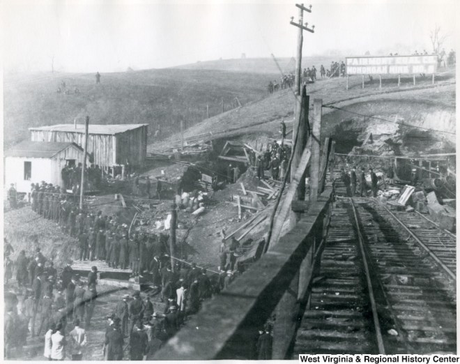
“A big mine fan, with auxiliary machinery arrived here on a special train from Pittsburg this afternoon at 4 o’clock, for use at the opening of Mine No. 8. Machinists and other workmen at once began work on installing it at the mine entrance and as soon as possible the machinery was in operation.” (CDT 12.8.07 pg. 1)
*When the train arrives, crews load the uninstalled fan onto an empty car or flat bed. The train pulls up slightly and crews unload the new fan and begin to haul it back across #8 trestle. The train continues on southbound to return the old fan to its proper mine in the Shinnston area.
*It takes approximately 45 minutes for this very experienced and driven crew to complete this task and get the fan running ventilation through #8 again. As far as Haas and the other onlooking reporters who may have known of this plan in advance, everything is going splendidly. Once ventilation has had some time to work its way through the mine, the state inspectors will perform the first formal fire and air check of #8.
“As soon as the fan was in operation the work of rescue was stopped at both Mine No. 6 and at Mine No. 8 for the purpose of testing the fan and ascertaining the result of the air current it would make.” (CDT 12.8.07 pg. 1)
*It does not take long for the new burst of air flowing through #8 to begin feeding these small “hot spots” throughout the mine. Smoke begins to fill the galleries and headings of the mine.
“New difficulties and complications have confronted the rescuers on every hand, but with only brief interruptions the work was continued until 3 o’clock yesterday afternoon. Then the fire drove all from the unexplored regions and the search had to be abandoned for the remainder of the day and for the night.” (TEW 12.9.07 pg. 7)
* = Author’s description of events. There is much conflicting information over the next 24 hours for several reasons and there will be an “Issues” post about this event and this author’s choices in the future. See ‘Dislaimer and Guide’ for more insight on this process.
More on How Death Gloated!